Role of Remote Sensing and GIS in Reservoir Management
Reservoir management, especially in the oil and gas industry, is beneficial for maximizing resource extraction and ensuring environmental sustainability. Traditional reservoir management methods typically rely on surface data collection, which can be time-consuming, expensive, and limited in scope. At this point, remote sensing (RS) and geographic information systems (GIS) can serve as powerful tools to improve our efficiency in managing oil reservoirs.
Reservoir Management in Oil and Gas
Efficient reservoir management is a cornerstone of successful operations in the oil and gas industry. It involves a complex set of practices and decisions aimed at maximizing the extraction of hydrocarbons from underground reservoirs while ensuring the longevity and sustainability of these valuable resources. The primary goals of reservoir management are to optimize production rates, minimize operational costs, and mitigate environmental impacts. Achieving these goals requires a thorough understanding of the reservoir's geological characteristics, fluid dynamics, and production history.
Key Components of Reservoir Management
- Reservoir Characterization: This involves creating detailed models of the reservoir's geological structure, porosity, permeability, and fluid distribution. Accurate characterization is essential for understanding how oil, gas, and water move within the reservoir. Traditional methods like seismic surveys, core samples, and well logs are fundamental to this process.
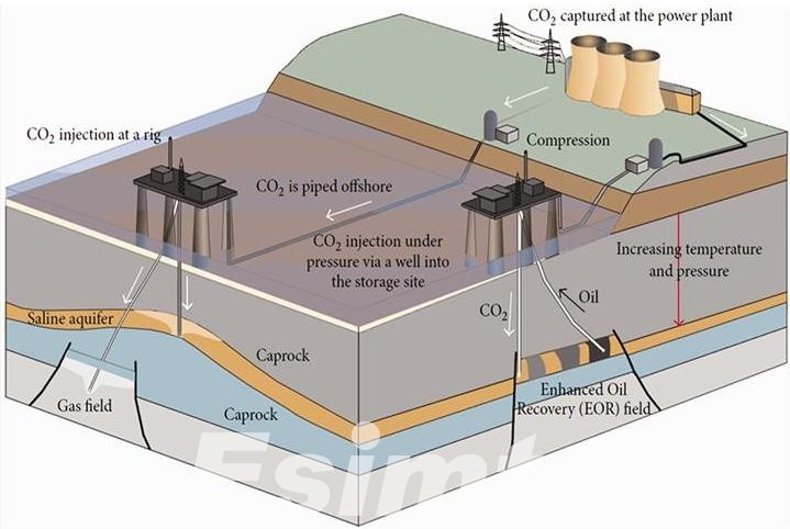
- Production Optimization: Reservoir engineers use various techniques to maximize hydrocarbon recovery. This includes selecting the appropriate drilling locations, well designs, and production methods. Enhanced oil recovery (EOR) techniques, such as water flooding, gas injection, and chemical EOR, are employed to increase the amount of extractable oil.
- Monitoring and Surveillance: Continuous monitoring of reservoir conditions is crucial for detecting changes that could impact production. This includes tracking pressure, temperature, and fluid composition in the reservoir. Data from monitoring systems helps in making real-time adjustments to production strategies.
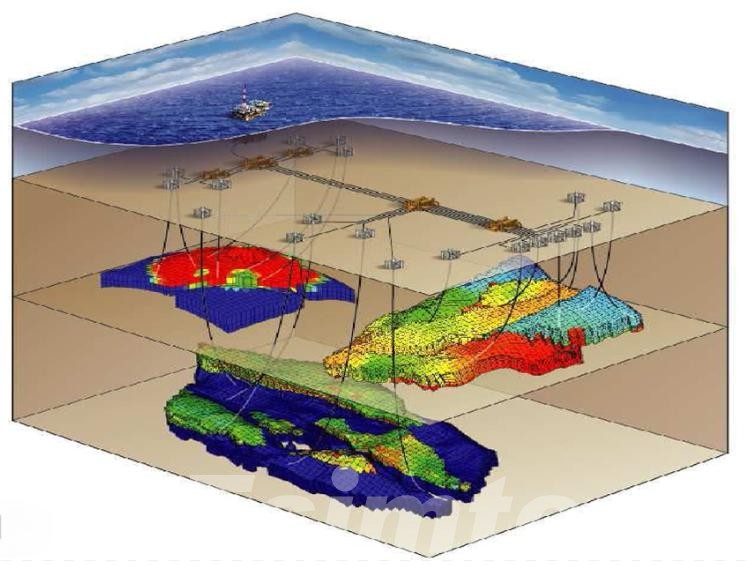
- Reservoir Simulation: Computer models simulate reservoir behavior under different production scenarios. These simulations help predict future performance, assess the impact of various recovery techniques, and guide decision-making. Reservoir simulation requires integrating vast amounts of data from different sources.
- Environmental Management: Responsible reservoir management includes minimizing environmental impacts. This involves monitoring for potential leaks, spills, and other hazards, as well as implementing measures to mitigate environmental damage. Compliance with regulatory requirements is also a critical aspect.
Challenges in Traditional Reservoir Management
Despite the advancements in traditional reservoir management techniques, several challenges persist:
- Data Limitations: Traditional methods often rely on limited data points, which can lead to uncertainties in reservoir characterization and performance predictions.
- Time-Consuming Processes: Conventional data collection and analysis methods are time-consuming, leading to delays in decision-making.
- Environmental Concerns: Traditional methods may not provide the necessary real-time monitoring capabilities to promptly address environmental issues.
- Operational Costs: High costs associated with extensive field surveys and well interventions can be prohibitive, especially for smaller operators.
The limitations of traditional reservoir management reflect the demand for advanced technologies that can provide more comprehensive, accurate, and timely data. This is where remote sensing and geographic information systems (GIS) come into play.
Remote Sensing and GIS in Reservoir Management
Remote sensing and geographic information systems (GIS) are emerging technologies that provide new ideas for reservoir management methods in the oil and gas industry. By providing detailed, accurate, and real-time data, these technologies enhance the ability to monitor, analyze, and manage oil reservoirs more effectively and efficiently.
What are Remote Sensing and GIS?
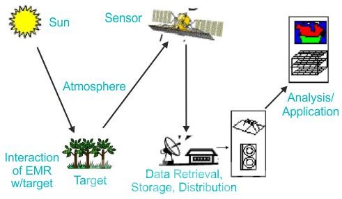
Remote sensing is the acquisition of information about an object or phenomenon without making physical contact. In the context of reservoir management, remote sensing typically involves the use of satellites, drones, or aircraft to capture high-resolution images and data about the Earth's surface. This data includes various forms of electromagnetic radiation, such as visible light, infrared, and radar, which are processed and analyzed to provide insights into the condition and behavior of reservoirs.
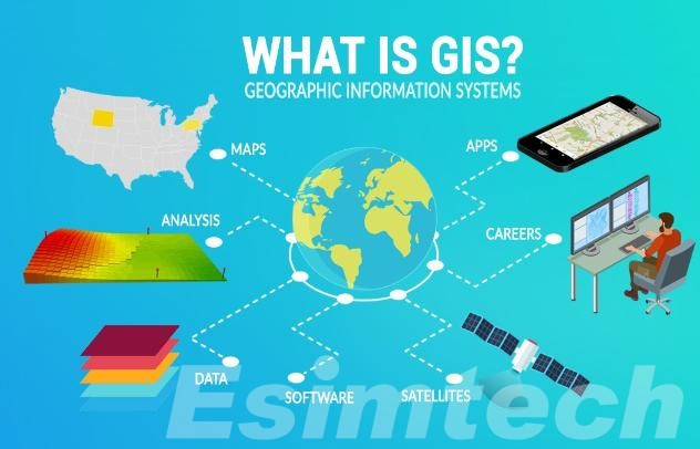
Geographic Information Systems (GIS) are systems designed to capture, store, manipulate, analyze, manage, and present spatial or geographic data. GIS technology integrates different types of data and provides tools for spatial analysis, mapping, and visualization. In reservoir management, GIS is used to create detailed maps and models of reservoirs, integrating data from multiple sources to provide a comprehensive understanding of reservoir characteristics and behavior.
Applications of Remote Sensing and GIS in Reservoir Management
Reservoir management in the oil and gas industry is all about maximizing hydrocarbon recovery while minimizing environmental impact. This requires a deep understanding of the reservoir's characteristics, fluid flow dynamics, and potential challenges. Here's where Remote Sensing (RS) and Geographic Information Systems (GIS) come in as a powerful duo:
Remote Sensing:
- Prospect Identification: Satellite imagery and aerial photographs can reveal surface features like fractures and vegetation patterns that might indicate potential hydrocarbon traps. Analyzing spectral reflectance from radar or LiDAR surveys can help identify promising geological formations hidden beneath vegetation or shallow layers.
- Environmental Monitoring: Monitoring drilling sites and surrounding areas for potential leaks or spills is crucial. RS data helps track changes in land cover, allowing for early detection of environmental issues.
- Infrastructure Planning: Planning pipelines, access roads, and other infrastructure requires understanding the terrain and potential obstacles. RS data provides detailed topographic information for route optimization and environmental impact assessment.
GIS:
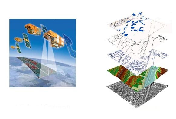
- Data Integration: GIS excels at integrating vast amounts of geological, seismic, well log, and production data from various sources. This allows for a holistic view of the reservoir, enabling better decision-making.
- Reservoir Modeling: The integrated data from GIS feeds into complex reservoir simulations, creating a virtual model of the reservoir's behavior. This model helps predict fluid flow, optimize well placement, and plan for enhanced recovery techniques.
- Production Optimization: By analyzing real-time production data and reservoir simulations within a GIS, engineers can identify areas of low productivity and adjust well operations to maximize recovery.
- Risk Management: GIS facilitates the identification of potential hazards like faults, fractures, or unstable formations near drilling sites. This allows for proactive measures to mitigate risks and ensure safe operations.
The true strength lies in how RS and GIS work together. Remote sensing data feeds into the GIS platform, providing valuable spatial context for all the other information. This allows for a comprehensive understanding of the reservoir's geological setting, optimizing every stage of reservoir management from exploration to production. Next, let’s take a look at the core benefits of integrating remote sensing and GIS in oil reservoir management.
Benefits of Integrating Remote Sensing and GIS
Integrating Remote Sensing (RS) and Geographic Information Systems (GIS) brings a range of significant benefits for oil and gas reservoir management. Let's delve deeper into some key advantages:
1. Enhanced Exploration Efficiency
Reduced Exploration Costs: Traditionally, extensive ground surveys were needed for exploration. RS data provides a cost-effective way to scan vast areas, identifying potential hydrocarbon traps and prioritizing areas for further investigation. This reduces exploration time and associated expenses.
Increased Exploration Success Rates: Combining geological and surface feature data from RS with subsurface data in GIS allows for a more comprehensive understanding of potential reservoirs. This leads to a more targeted approach, increasing the success rate of exploratory drilling.
2. Improved Reservoir Characterization
Detailed Geological Mapping: High-resolution RS data aids in detailed geological mapping of the reservoir area. Identifying faults, fractures, and other structural features helps in building a more accurate subsurface model.
Geospatial Understanding: Integrating diverse data sets within GIS provides a geospatial understanding of the reservoir. This includes factors like formation thickness, fluid properties, and pressure variations, leading to a more precise model for production planning.
3. Optimized Production Operations
Real-time Monitoring: Integrating real-time production data with reservoir simulations allows for dynamic adjustments to well operations. This helps optimize production rates, identify underperforming areas, and ensure efficient resource utilization.
Reduced Environmental Impact: GIS enables precise monitoring of drilling activities and potential spills. Early detection of environmental issues allows for swift mitigation strategies, minimizing footprint and environmental damage.
4. Improved Decision-Making
Data-Driven Insights: The combined power of RS and GIS facilitates data-driven decision-making. By visualizing complex data sets on a map, engineers can gain valuable insights into reservoir behavior and predict future production trends.
Improved Communication and Collaboration: A shared GIS platform allows all stakeholders involved in reservoir management to access and analyze the same data. This fosters better communication, collaboration, and more informed decision-making across teams.
Overall, integrating Remote Sensing and GIS creates a holistic view of the reservoir, leading to smarter exploration, optimized production, and a more sustainable approach to oil and gas resource management.
Conclusion
The role of remote sensing and GIS in reservoir management should not be underestimated. These advanced technologies provide the data and tools needed for more accurate and efficient monitoring, analysis, and management of oil reservoirs. With the continuous advancement of technology, the integration of remote sensing and GIS will become more important in addressing the challenges of modern reservoir management.